RAYON D’OR & VAUQUELIN GOLD PROPERTIES
RAYON D’OR & VAUQUELIN GOLD PROPERTIES OUTLINED
Technical Information:
Rayon d’Or and Vauquelin Gold Properties are located within a major gold mining camp in Northwestern Quebec, in the center of Vauquelin township (NTS 32C03), approximately 40 km east of the town of Val d’Or. Combined, the Properties consist of 37 contiguous map-designated claims covering 2,129 hectares (5,261 acres). The Rayon d’Or Property consists of 6 claims covering 345 hectares (853 acres) and the adjacent Vauquelin Property consists of 31 claims covering 1,784 hectares (4,408 acres).
Both properties are underlain mainly by intermediate to mafic volcanic rocks with associated synvolcanic intrusions of the Val d’Or Formation. The Pershing-Manitou granitic pluton is also present in the northeastern extremity of the Vauquelin Property.

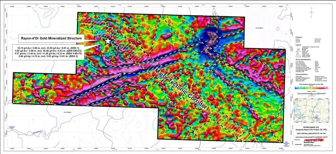
Rayon d’Or
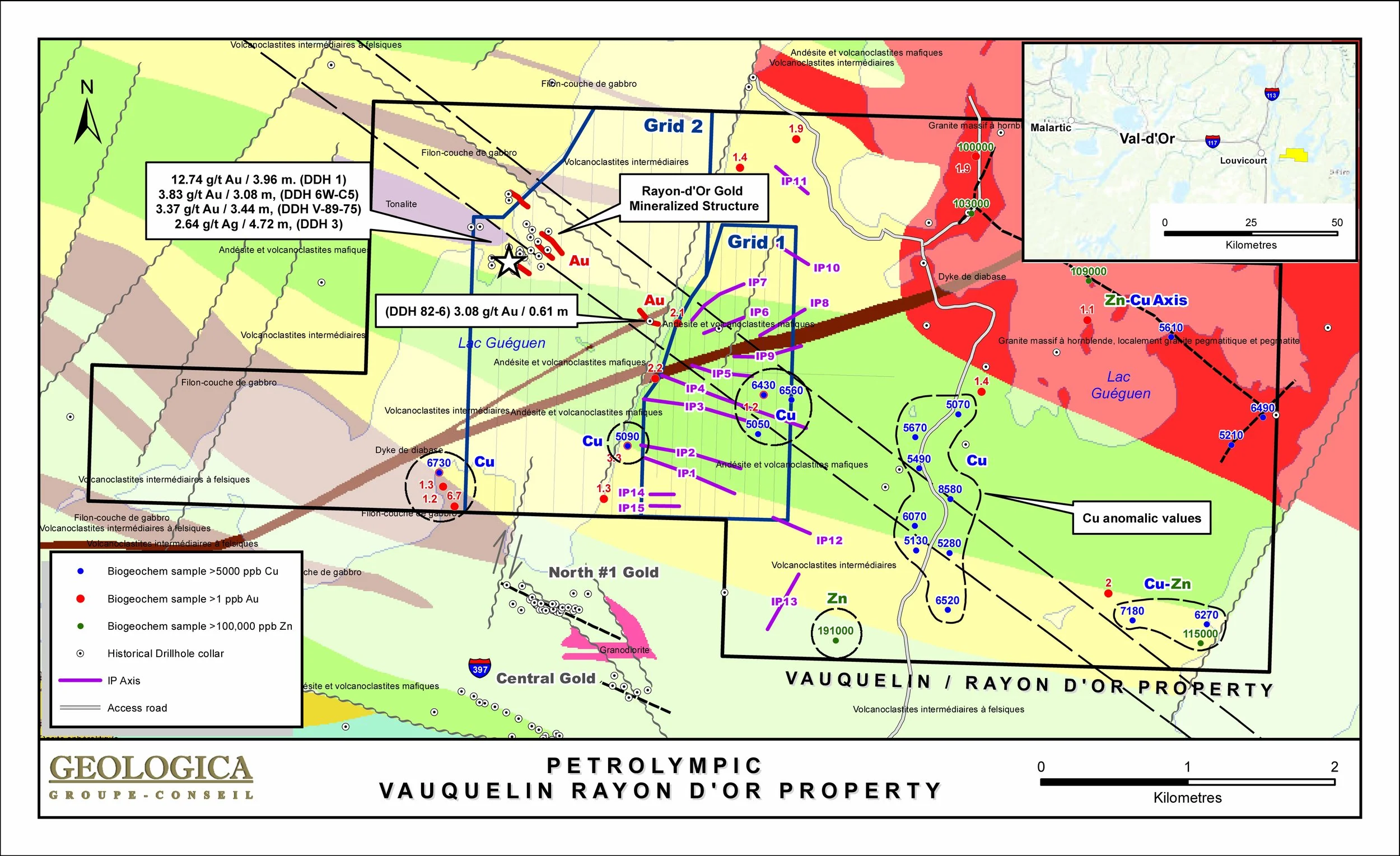
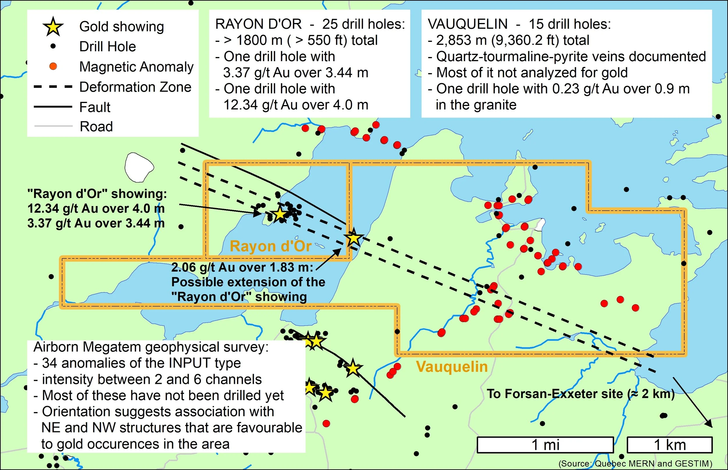
In the Rayon d’Or Property, previous work has identified several sheared, altered, schistozed and mineralized NNW-SSE structures steeply dipping to the SW. These structures are hosted within rhyolites, locally porphyritic andesites and several porphyritic felsic dykes. The mineralized structures are injected with quartz-carbonate veins and veinlets which are associated with sulfides. The sulfide mineralization mainly consists of pyrite, pyrrhotite, chalcopyrite and gold. Previous drilling has delineated two auriferous zones with most significant intersections of 12.34 g/t Au over 4.0 m in hole M-1 and 3.37 g/t Au over 3.44 m in hole V-89-75.
Geoscientific compilation of available data (geophysical, geological and geochemical) demonstrates the most likely orientation of the mineralized structures as well as their possible lateral and depth extensions. The presence of gold (Au), silver (Ag), copper (Cu) and zinc (Zn) geochemistry soil 'B' Horizon, several Induced Polarization (IP-Resistivity) anomalous zones and axes, as well as two gold mineralized zones intersected by drilling confirm the favourable potential of the Rayon d’Or Property and its likely extension to the Southeast into the Vauquelin Property.
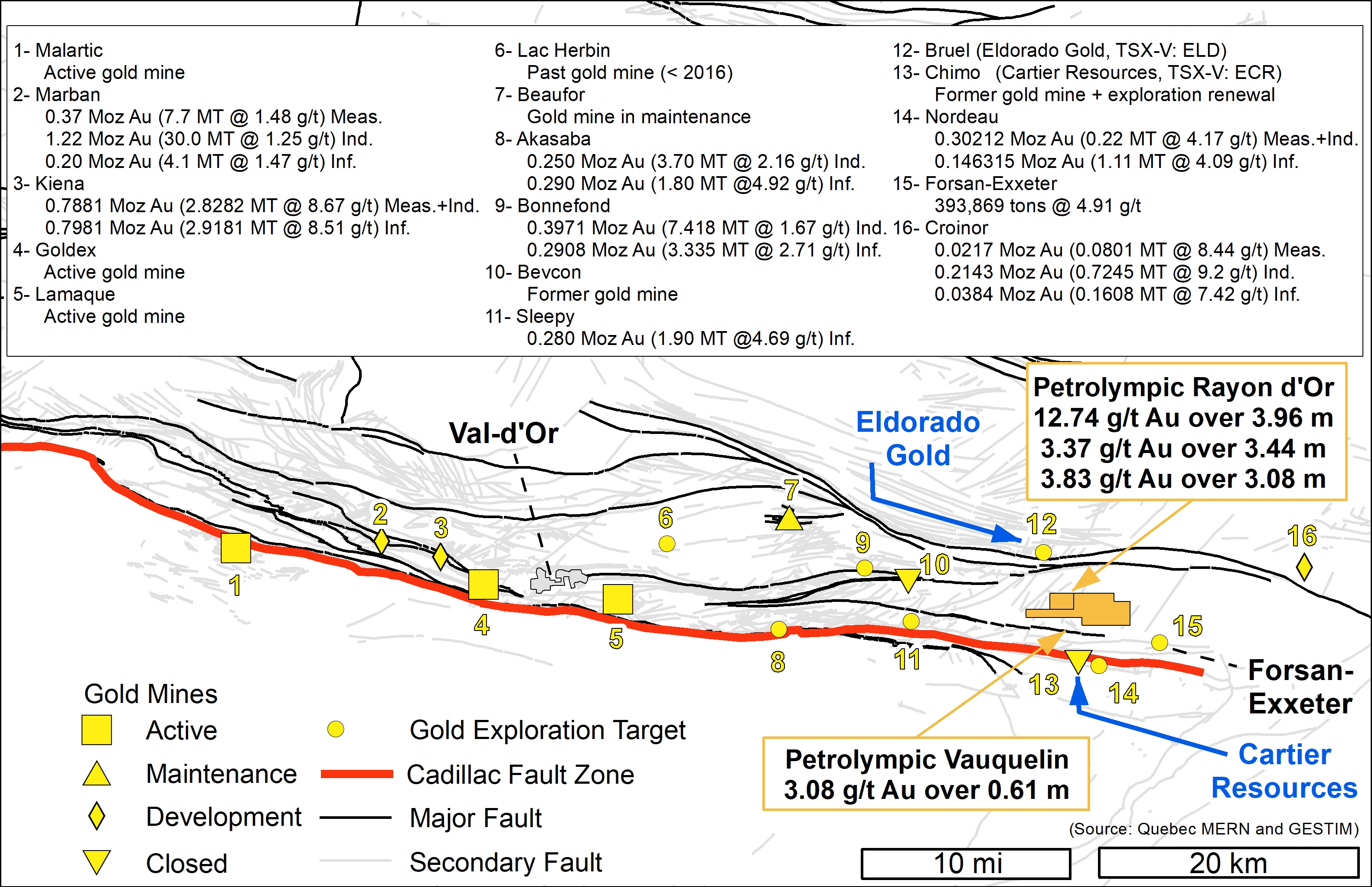
An East-West trending structure to the North of the Property includes the Croino gold deposit containing proven and probable reserves totalling 602,994 tonnes at a grade of 6.66 g/t Au (Source: Monarch Gold Corporation website).
Looking further towards the West of the Property along the same East-West deformed geological units, several base metal and gold showings are present along with the old Bevcon mine which produced between 1945 and 1967 a total of 438,000 ounces of gold grading 4.3 g/t Au (Source: SIGEOM/MERN).
Vauquelin
In the Vauquelin Property, previous work includes geophysical surveys and 15 diamond drill holes totalling 2,853 meters. Drilling results have shown intersections of gold in some holes, including a showing along Lac Guegen-Baie SW close the Rayon d’Or Property with 2.0 g/t Au over 1.8 m in hole 82-6, intersected at a depth between 27.01 m and 28.81 m along the hole. This gold zone is hosted in a shear zone intersecting a unit of felsic volcanic (rhyolite and quartz-biotite schist) and containing quartz-pyrite veins. It may be the southeastern extension of the host structure discovered in the Rayon d’Or vein-type deposit. Historical polls mention two gold zones, one of which is associated with quartz-carbonate-tourmaline-pyrite veins in a porphyritic andesite and the other is contained in a quartz-chlorite-tourmaline-pyrite veine.
Another drilling survey (V-89-82) carried out in the pluton returned an anomalous value of 0.23 g/t Au over 0.9 m associated with a diorite mineralized in pyrite. Quartz-tourmaline-pyrite veinlets associated with shear zones are mentioned in some drill holes carried out to verify geophysical anomalies detected in the pluton. Although these mineralized zones have not been analyzed for gold (GM-38615), the quartz-tourmaline-pyrite veins represent one of the main mineralization types in Val d’Or area.
The presence of dominant Northeast and Northwest structural features revealed by past geophysical surveys further enhances the potential of this gold property.
A Megatem-type airborne survey covered the entire property. This survey locates 34 INPUT-type anomalies on the Property, varying in intensity from 2 to 6 channels. The majority of these electromagnetic anomalies were not investigated during previous exploration drilling campaigns. The orientation of electromagnetic anomalies suggests their association with Northeast and Northwest structures which in this sector are generally suitable for gold anomalies.
A series of Input-type EM anomalies also runs along the contact between the Pershing-Manitou pluton with volcanics and these WNW-oriented anomalies may coincide with a mineralized structure. Other anomalies located inside the pluton that do not correspond to a diabase dyke, have never been drilled in the past and represent targets for gold exploration.
Approximately 7 km to the East along the main structure discovered in Rayon d’Or & Vauquelin, the Forsan-Exxeter gold zone is also oriented towards the northwest and may extend up to the Property. This gold zone has historical resources totalling 393,869 Mt grading 4.91 g/t Au (Source: L. Perron, 1988, GM-47652 at MERN).
Approximately 4.5 km South of the Property, an East-West trending mineralized structure hosts the old Chimo mine with indicated resources of 4,017,600 tonnes at an average grade of 4.53 g/t Au and inferred resources of 4,877,900 tonnes at an average grade of 3.82 g/t Au (Source: Cartier Resources Inc., press release dated May 5, 2020).”
MAPS
Resource Area Map

Geological Map
Historical Geophysical Survey Map
Geophysical Survey Map

IP and biogeochemical surveys